LED lets archaeologists see the past in a new light
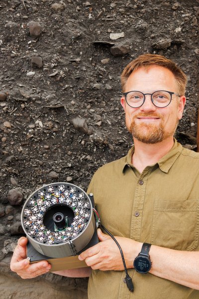
Geologist Søren Munch Kristiansen has worked with archaeologists from Moesgaard to develop an LED flash that uses all the colours of the rainbow. Combined with a camera, it can highlight traces in the soil that are otherwise difficult for archaeologists to see during excavations. The device is portable and relatively inexpensive.

An archaeological excavation resembles eating a layered cake in one crucial respect: once a layer is gone, you cannot put it back.
And if two layers in the cake are the same colour, it can be difficult to see where one ends and the next begins.
Of course, you could taste your way through it – but that would rather ruin the cake.
Archaeologists face much the same problem during excavations. Soil layers can be difficult to distinguish from one another, sometimes forcing archaeologists to dig into them simply to find out what they contain.
Researchers from Aarhus University and Moesgaard have now developed a relatively inexpensive camera system using LED light that can give archaeologists an extra way of looking at the soil before the trowel takes over.
The system illuminates the same surface with different wavelengths of light and can highlight differences between layers and materials that are difficult to spot. This can give archaeologists clues about what deserves closer attention and where it may be useful to take samples.
“There are surprisingly many challenges involved in looking at soil. We wanted to make things faster, clearer and better – while keeping the system affordable for use in the field. It is simply a way of rethinking the light,” says Professor Søren Munch Kristiansen from the Department of Geoscience at Aarhus University.
The system is called LEDMSI – LED multispectral imaging – and is described in a new study in the Journal of Archaeological Science.
16 different ways of looking at the same soil
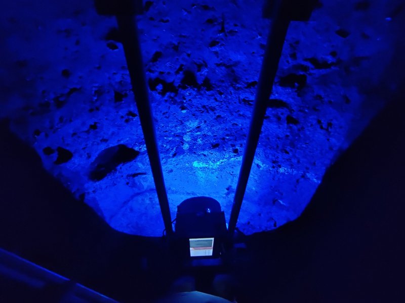
Instead of relying only on the light our eyes can see, the system photographs the same surface repeatedly while the multispectral flash illuminates it in turn with LED light at 16 different wavelengths.
The wavelengths range from near-ultraviolet through visible light to near-infrared.
Different materials absorb and reflect light differently. Two soil layers – or tiny archaeological finds – that look identical to the human eye may therefore behave differently when illuminated with other parts of the light spectrum.
The computer then combines the information from the images and makes some of these differences stand out more clearly.
You might say that the system tastes the layered cake with light.
Tested at Sorte Muld
The researchers tested the first prototype at Sorte Muld, an Iron Age site on the Danish island of Bornholm.
Here, thick, dark cultural deposits lie on top of one another after centuries of human activity. For an archaeologist, it can be difficult to determine exactly where one layer ends and another begins.
With the first prototype, the researchers could not analyse the results while they were still at the excavation.
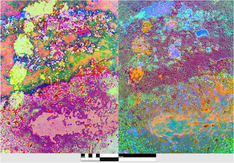
“The images looked almost psychedelic, and we only really saw the result when we came home and analysed them on the computer. But then we could see new layers and changes in the fill that we could not see with the naked eye,” says Søren Munch Kristiansen.
The multispectral analyses revealed differences in the sediments and stratigraphic boundaries that did not stand out clearly in ordinary colour photographs.
The computer could not tell the archaeologist exactly what each individual layer was. But it could point out that something was different.
And that is the next step in the development: not only revealing the differences, but also helping archaeologists understand them while they are still in the field.
From Bornholm to graves in northern Jutland
Since the test at Sorte Muld, the system has been further developed.
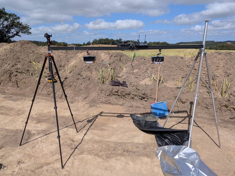
A newer and faster version with two LED units and an improved camera has recently been tested at Fredbjerg in Vesthimmerland, northern Jutland, as part of the IDUN project. Here, archaeologists are investigating a cemetery dating from the late Viking Age and early Christian period.
Preservation conditions are poor, and the skeletal material has almost completely disappeared in some graves.
“The skeletons could almost only be seen as shadows after a thousand years in the ground. So it is not always obvious where you should look or take your samples,” says archaeologist David Stott from Moesgaard, who has helped develop the system.
At Fredbjerg, the multispectral images were not merely used to show differences. They were also used to plan where samples should be taken.
“We used the new data to plan our sampling. The camera could show us areas where it was most relevant to look – for example for remains of bone or material from the area around the abdomen,” says David Stott.
The Fredbjerg experiment is not part of the published Sorte Muld study, but is a test of the next generation of the system.
Soil does not come in neat layers
This kind of assistance can be important because archaeological deposits rarely resemble a tidy stack of pancakes.
People have dug holes, filled them in again, moved soil around and built on top of earlier activity. Objects found in different layers may therefore come from the same period. Conversely, things lying close together may be very different in age.
“If we can see more clearly how soil was dug up and deposited again, we get both better documentation and a better understanding of the site. It can also help us choose the right places to take samples for things such as dating,” says Søren Munch Kristiansen.
Now the computer has to learn what it is seeing
The first prototype could take up to around five minutes to capture a series of images. The newer version tested by David Stott at Fredbjerg can complete the full sequence in around 30 seconds.
The next step is to process the images almost in real time on a computer – and perhaps eventually on a smartphone – while the archaeologist is still in the field.
But the researchers want to do more than simply display the differences quickly.
They are also working on software that uses machine learning to recognise patterns in the multispectral images and help archaeologists work out what is what in the soil profile.
“The difficult part is teaching an algorithm to understand what is what. That is something we will start working on in the coming versions,” says Søren Munch Kristiansen.
The idea is not for the computer to replace the professional judgement of archaeologists or geologists. Rather, it should act as an extra pair of eyes, pointing out areas that may resemble bone, particular types of soil or other materials that deserve closer examination.
As Søren Munch Kristiansen puts it:
“At the moment, the problem is that the archaeologist and I, as a geologist, basically have two settings: glasses off or glasses on.”
He hopes that systems like this will eventually become standard equipment on archaeological excavations.
“I hope that in ten years, bringing a system like this to an excavation will be as normal as bringing a digital camera,” he adds.
For now, however, there is one very practical limitation:
The measurements require other light to be kept out.
So Søren Munch Kristiansen has invested in a rather less high-tech accessory: 100 metres of the kind of black plastic farmers use to wrap silage.
Additional information | |
| We strive to ensure that all our articles live up to the Danish universities' principles for good research communication(scroll down to find the English version on the web-site). Because of this the article will be supplemented with the following information: | |
| Funding | The Augustinus Foundation |
| Collaborators | National Forensic Centre (NKC) demonstrated how Alternative Light Source methods are used in forensics |
| Read more | The article “Seeing the past in a new light: LED multi-spectral imaging as an interpretative aid for archaeological excavation” in Journal of Archaeological Science |
| Contact | Associate Professor Søren Munch Kristiansen, Curator David Stott, ph.d. |